Hiking the Via Alpina
The boots: seams fraying, insoles permanently stinky, and every square inch of the outside covered in cow poo, goat muck and sheep s$%t – yup it was time to trade them in for new ones. And I did, leaving the old ones in the boot shop in Vevey. For a mad, fleeting moment I thought of having them bronzed – but no. I had 604 photos to prove that I’d just trekked 19 days over 360 kilometres with more than 20,000 metres of elevation over the high passes from one end of Switzerland to the other – solo. My feet were taped up, my left knee was giving out, but darn it, I’d done what I’d set out to do. And it felt pretty darn good.
It was not this summer’s smoke that drove me to Europe. No – it was simply a browse through Facebook and a post from a friend of a friend with a link to the Via Alpina home page. I’ve hiked a lot in Switzerland and love it – so for me this was prime clickbait. I read it: hike from east to west, climb over the passes; start in Sargans on the border with Lichtenstein and finish in Montreux. Eighteen days! Carry a light pack and stay in village inns or mountain huts every night!
It was irresistible.
A week later I was flying to Zurich.
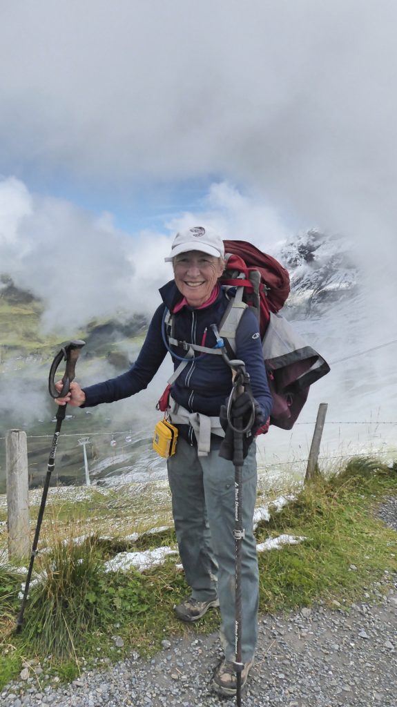
I’d packed adequate clothing for all sorts of weather, a bare minimum of toiletries and my iPad in my multi-day pack. Still, it weighed in at about 25 pounds. Light enough, I told myself. And of course, I’d left enough room for chocolate at the end of the trip.
My connections went smoothly, I bought a train ticket to Sargans at the Zurich airport and was whisked away to my start point on the eastern border of the country.
Hotel reservations or hut reservations along the way? Who needs them? Plans might change… I’ll probably want a rest day somewhere.
One hotel was open in Sargans at 6 p.m. and it was full. I wandered the town. I talked to locals. Surely there had to be a bed somewhere.
Apparently not.
After an hour of plodding, I decided I would sleep in the train station. Feeling dejected I tried The Post one last time – a cancellation maybe?
Yes – a cancellation! Happy dance – or at least there would have been if I’d had the energy. My “single” room was the cancelled suite. Lovely. A hot shower, laundry (a daily must), a hearty Swiss meal of eggs, potatoes and cheese, because the Swiss put cheese on everything. And bed.
Stage 1: Sargans – Mels – Weistannen
The idea of stage one is to start you off easy – say about a 5-hour hike of 13K crossing a pass with an elevation gain of only 650 metres. What my Cicerone guidebook didn’t take into account was severe jetlag. Nor did it say anything about 30-plus degree heat and a fair amount of humidity.
Sargans is a sizeable town. Happily, finding my way through it was a cinch thanks to brilliant Swiss signing. At every corner and intersection, a yellow arrowed sign plus the Via Alpina green flashings.
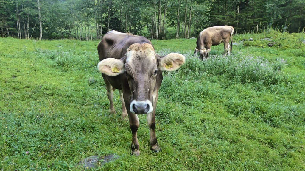
I walked through pretty Swiss countryside, loving the chalets and the jingle of cowbells and of course, the cows – so photogenic. (I think they know about tourists and spend their time at the side of the trail posing).
I wandered over the gentle pass and drifted into my next lodging (rooms available!) in the tiny village of Weistannen at least an hour ahead of the guidebook schedule and opted to save money by sleeping in the dorm.
Jetlag was still with me, not helped by prolific snoring from another occupant. Oh well!
Stage 2 – Weistannen – Foo Pass – Elm
I was prepared – today the real work would begin – 1300 metres up to the Foo Pass and 1320 down to the next village – Elm. Getting up early was not a problem. At 6 a.m. every church in the village decided it was time for us to rise – all of us. The clarion call continued for a good 15 minutes – no snooze buttons. We were awake and ready to go.
The first directional sign out of the village indicated 5.5 hours to the pass. Well then. Does that time take a 25-pound pack into account – a pack that was leaving bruises on my hips bones and tailbone?
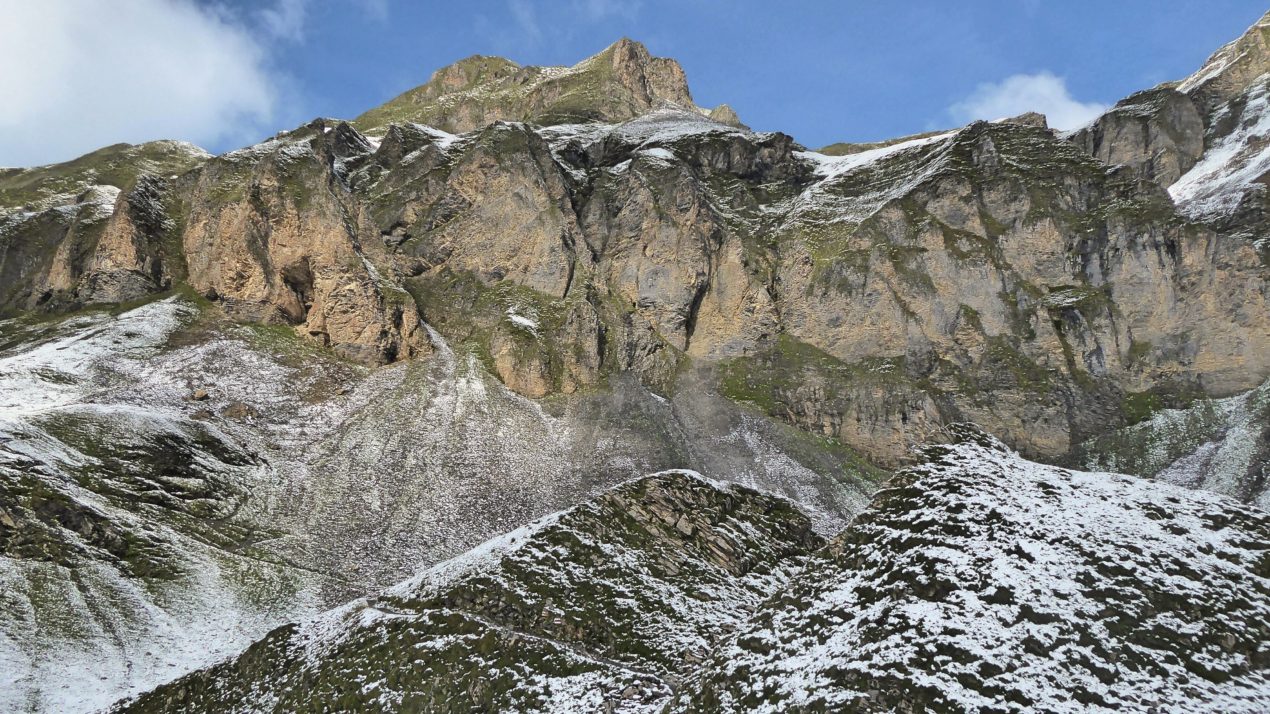
The trail was steep in spots, lovely in many ways, shaded in places (whew!) and open and hot in the alpine meadows. The views opened up almost immediately and my camera came out.
And after slogging uphill for almost 6 hours, there I was! Foo Pass! Lunch: a sandwich that contained half a pound of cheese from the neighbouring farm plus pickles and tomatoes from the innkeeper’s garden and all of that on freshly baked brown Swiss bread slathered with fresh Swiss alpine butter. Yes – this could well rank as the best part of the day.
After that came the long, long downhill. By the time I limped into Elm my feet were hurting in places that have never hurt before, like between my toes. That night – a private room in a small guesthouse with a shower down the hall.
Stage 3 – Elm – Richetlipass – Linthal
Day 3: one of the big ones: 24.5K, 1490 metres elevation and 1820 metres straight down. Time estimate? Nine hours.
I was on the trail by 7.30 trying to escape some of the heat of the day.
Fat chance of that happening. By 11 a.m. I had wolfed down a power bar thinking, the pass can’t be that much farther.
It was. I went through my two litres of water and filled up at a farmhouse – cold and fresh straight from a mountain spring. When I finally caught sight of the pass it seemed impossible – but you just keep putting one foot in front of the other. And then, hurrah! There I was. But not there. A couple of hikers who had just crested the pass from the other side set me straight – oh no – there are two passes today and that one you see way over there across the valley? That’s the pass.
And so down and down all that painfully won elevation, across a gorgeous valley and then up and up and up and finally – hurrah! The pass!
Going down was steep, arduous, beautiful and, toward the end, a race against time: black thunder clouds moving in fast. I squeaked through the hotel door in Linthal 5 minutes before the heavens opened. Two couples hiking about an hour behind me were not so lucky.
Stage 4 – Linthal – Braunwald, Urnerboden
With only (!) 1010 metres of ascent on the schedule, it was going to be an easy day – easy enough for me to reflect on my experiences to date. First, Swiss hospitality is awesome. When I asked the hotel owner where I could buy a sandwich for lunch, he waved me away and presented me with a monster cheese sandwich and said, “no charge.” Another example, I started the day going 600 metres straight up out of town. A Swiss woman with legs the size of tree trunks barrelled by me, stopped, asked where I was going and proceeded to give me every tip she knew about how to make my day flow smoothly. Mind you, she did all this in Schweizerdeutsch, a dialect that might as well be Swahili. I understood every third word (maybe) and nodded along, smiling like an idiot and saying “Danke” an awful lot.
There was a lot of uphill to the pass. I alternated dripping sweat, gasping for breath and thinking I was going to keel over with being in awe of the views.
However, more important were my reflections on lunch. My sandwich: a pickle and huge hunks of alpine cheese from a local farm and again, that remarkable sweet butter that is so fresh it actually is sweet. The hotel owner had slathered butter on this bread so thick he may as well have put the entire brick in it. I could write a poem about this butter. Maybe I will. It is the food of the gods.
I limped downhill into Urnerboden, a tiny village with one guest house and a miniature store that is part of the church(!) My feet had numerous hot spots. Band-aids were not doing the trick. Neither was moleskin. Duct tape was my best solution but not perfect.
I’d been noticing that fellow hikers on the same route were doing a bit of “cheating” – taking the odd gondola up a hill or the bus to avoid some of the walking and elevation. I was beginning to think – maybe it’s not the most awful idea.
Stage 5 – Urnerboden –Klausenpass – Altdorf
A nice, easy day this one: 26K and only 700 metres up and 1610 metres down (!). Okay – but still. Pretty good. So good that I decided to take the alternate route into a side valley that had a pretty waterfall and was highly recommended by the guidebook.
What the book failed to mention was that the alternate was like a shortcut (longer) and that it would require going up a second pass.
It did, however, meander through a pretty village and it did give me a lovely close encounter with goats. But after that, in the heat of the afternoon, I had to climb up again – and up and up and then down. It was when I arrived in a small village and realized I still had a lot of kilometres to go to reach the town of Altdorf that I hopped on a passing bus. Yes – I cheated. And I’m glad I did. It was 15 minutes by bus to the centre of town – a large town – home of William Tell – and no room in any hotel anywhere.
No problem. I hopped another bus to the small suburb Attinghausen where there was a room in the basement of a hostel. Whew! Maybe it was time to re-think reservations.
Stage 6 – Altdorf – Surenenpass – Engleberg
There was never a doubt in my mind that this was going to be a cheating day. Distance: 29K, elevation gain – 1900 metres – time 10 hours and 30 minutes.
I could cut off a good hour by taking a small gondola up to Brusti – a ski hill, thus cutting off a tiresome climb through a forest.
So, I did that without a pang of guilt.
It was the first day I pulled on layers. It was wet, windy and wild but through the drifting clouds and showers, there was amazing alpine beauty – and a host of rare black alpine salamanders. I had to keep my eyes firmly fixed on the trail for fear of stepping on them. Rare? Really?
After a long, hard hike to the pass, cresting it was one of those “wow” moments – higher and higher peaks revealing themselves as I headed closer toward the Berner Oberland and its famous mountains.
After the wow? Four hours down to Engleberg on increasingly sore and blistered feet. I walked into the first hotel – yes, they had a room and yes, it was private and yes, it had a hot shower and a comfy bed. On other words, everything I could possibly ask for – well, except maybe a masseuse and a foot doctor.
Stage 7 – Engleberg – Jochpass – Engstlenalp
Again – wet, and foggy – again – just do it! Hey! It’s only 1230 metres up and (even better) only 400 metres down to a mountain hut for the night.
And the mountains are getting big.
I plowed on and on, carefully searching for those very excellent trail markings (usually painted on stone) that the Swiss are so meticulous about – but which are a bit hard to find when the clouds and fog are so thick you can’t see more than a foot in front of you.
How thick was the soup? Well, I hiked up and up and up and finally noticed a building looming out of the fog. Had I taken a wrong turn? Did I miss a sign? I walked to the far side of the huge building – it seemed to be all downhill from there. Well, where was my trail up to the pass? I walked up the meadow thinking maybe I’d find the trail. Nothing. And then – voices! I hurried down toward them and encountered a group of Swiss hikers. Where is the Jochpass please?” I asked. “I seem to have lost it.”
“This is it,” they said.
“?”
“Yes – this is a restaurant and you just go around to the other side, head downhill on the trail and you’ll be at Engstlenalp in no time.”
Well! How about that! I’m at the top!
And down I went to Engstlenalp – a huge hut that has been there forever it seems. Warm, welcoming, and a wonderful place to dry out my boots and myself.
And then the next morning dawned, with clouds lifting and drifting across the face of the mountains, the morning sun burning holes in the air, gold light glinting – walking out into pure magic.
Stage 8 – Engstlenalp – Planplatten – Meiringen
The guidebook had warned that hiking across Planplatten was to be done only in good weather. If there was any doubt, take the valley route. I trusted the morning sun and headed out to the ridge and the pass.
And this is where words fail me. Frost coated the grass and as I rose higher and higher, snow all around me. I was alone in a world that might have been the fantasy work of some mythical ice queen. And I was glad my camera battery was fully charged. I was also glad I’d done minor surgery on my blisters, which had turned into blood blisters – popping them made a difference!
And this was the first day I fell – twice! Once in a giant field of cow patties – I will spare you the details.
This was also the day that proved for the millionth time that every time you look far ahead (and usually up) and think to yourself, “Well, this is hard but at least I don’t have to hike on that trail!” – you always have to end up hiking on that trail.
This was also the day that I decided I’d had it with cows. No longer cute – just in-your-face pooping machines.
Arriving in Meiringen was one of those arrivals – after 1870 metres of downhill, it was all about, thank goodness I’m here! Just give me a bed, a shower and a plate of potatoes and cheese!
Stage 9 – Meiringen – Grosse Sheidegg – Grindelwald
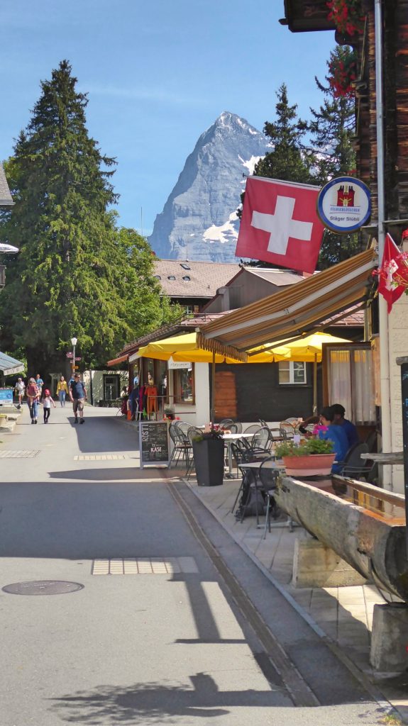
Piece of cake today – only 1410 metres ascent. But what really made it easier was the fact that I was now in familiar territory. For the next couple of days, I’d be in the part of Switzerland I’d hiked so often. The weather was fine. The sky was blue and I climbed up to the Grosse Sheidegg in awe of the north face of the Wetterhorn and soon – the north face of the Eiger.
I admit to taking a slightly wrong turn and coming up too high on the ridge (pass) and having to come back down – so what’s another 50 – 100 metres right?
Because I was sick of cows, the fates sent me goats – but not just any goats; very strange alien goats with ibex-like horns that regarded me as though I was the one who was odd.
Once again, it was a long, long walk down to Grindelwald. But this is a good-sized little alpine town. My first stop: the drug store where I spent a small fortune on foot-related items: Band-Aids, second skin, padding – and then played doctor again in my very nice little hotel room.
I comforted myself with knowing that I had one more big pass the next day and then a rest day.
Stage 10 – Grindelwald – Kleine Scheidegg – Lauterbrunnen
Another sunny day – another footsore day – another day with spectacular views opening up. By this time, the pack was sitting perfectly and my hips and tailbone were good. It had become a routine: get up in the morning, eat breakfast, pack, heave the pack on my back, go outside and start walking. Reverse it at the end of the day. The beauty of walking: everything is in the now. No decisions to make – nothing to do but walk. Follow the trail.
Now, in the centre of the Berner Oberland, the views were constantly startling, beautiful, breath-catching. At the top of the Kleine Sheidegg, mayhem. This is where the trains from both valleys arrive to spill people out to restaurants, a huge hotel and, most importantly, the train that burrows through the mountains to arrive at Jungfraujoch high up on the shoulders of the Jungfrau and at the top of the Aletsch glacier.
This was fine because that left the trails free for odd people like me who like to hike. And so I hiked, through beautiful meadows with inspiring views until my feet said: “No more!” I cheated. I took a train from Wengen to Lauterbrunnen, cutting off the last hour of descent. Did this help? Well – I had taken the precaution of booking a room in this busy place – but the room was in a guest house that was decidedly not the advertised 300 metres from the train station. When I finally found it, I’d been walking for nearly an hour and it was closed!
Another hour to backtrack and find another lodging place. And that’s when I made my decision. I’d been planning to hike to Murren the next day and then take the rest of the day off. Choice number two: take the gondola to Murren and take a full day off.
No guilt.
Stage 11 – Lauterbrunnen – Murren – Sefinenfurke – Griesalp
And so, after taking the gondola to Murren and spending a day wandering around the village in my oh so comfy “camp” shoes and napping and eating a monster veggie burger and enjoying the warmth and sun, I set off for Griesalp (having wisely reserved a room in the mountain hut) on a day that was less than stellar. I was about to cross the three highest and most photogenic passes. The clouds were so low to the ground I could almost not see the grass.
But when you’re walking across a small country, you take what you get – and you make the most of it. So I reveled in the beauty of swirling clouds and mist and rippling streams and – well – cows.
The Sefinenfurke was not an easy pass: the last steep scree slope came with rope assists, and the ridge: a sharp notch in the giant rock walls – the down trail on the other side eased by steps with cable assist. Although why the cable would be at ankle height was a mystery I couldn’t quite solve.
Late that afternoon, dripping wet, I arrived at the mountain hut above Griesalp. It was lovely and old and charming and warm. The only other occupants: the young British couple I’d been hopscotching with on the trip and two Swiss couples who were doing a truncated version of the VA.
We chatted over dinner about the joys and tribulations of through-hiking – and of course the weather. The next day we would attempt the Hohturli, the big one – the pass that everyone anticipated and feared in equal measure. The guidebook described it as thrilling, airy, scary and definitely not for the faint of heart. At almost 3,000 metres it was the highest and toughest of the trek. It was also not to be attempted in bad weather.
The hut’s keeper shook her head. “Snow,” she predicted.
Stage 12 – Griesalp – Hohturli – Kandersteg
I woke up early – opened the window in my room – low clouds but no rain. I ate breakfast. The Swiss couples were unsure. Should they go for it? The women said “no.” The men thought perhaps they should try. The hut keeper shook her head.
I shouldered my pack, walked out the door and looked up at the sky. I shrugged. “I’m going to do it,” I said.
And I walked off down the trail. I was 20 minutes into the beginning stages of the climb when the heavens opened.
I sighed, regretting my own common sense, and turned back. There I found my traveling companions strapping on packs on the porch. “We’re headed to the village to catch the bus,” they said.
“Me too,” I said.
And so we caught the bus to the nearest train station and then boarded the train to Kandersteg. It rained all morning. Snow on the pass. After a nap, I assessed the situation. I had missed seeing the Blumlisalp Massif and the magnificent peaks above the village. But – I could still partly make up for this. The trail I would have been on winds down past the Oeschinensee, reputed to be the most beautiful lake in all of Switzerland. I could still hike up in the drizzle and rain, see the lake in about two hours, and then come back down.
I did that. The only real issue was that I wasn’t quite sure that I had actually arrived at the lake. I stood at the edge. Yes, I could hear water lapping at the shore. I took a quick photo – it was a grey blank. Was the lake beautiful? Possibly – I had no proof.
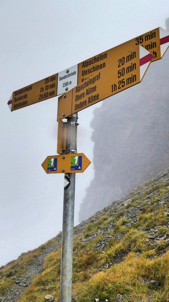
Stage 13 – Kandersteg – Bunderschrinde – Adelboden
Another day – the third “big” pass of the trip – 1300 metres elevation – destination – Adelboden. Yes, it was raining. I had faith it would stop. I set off. In retrospect, it was rather cute that when the trail wove its way through a farmer’s field I took care to lift my feet high so as not to get my boots too wet. Half an hour later my feet were squishing inside my boots.
It rained all the way up – four hours. The rain clouds parted for a total of 20 seconds at the very top. I whipped out my camera, took a photo to prove I’d been there and then it rained. All. The. Way. Down.
Ironically, the last half hour to Adelboden involved a steep uphill climb because the village was not exactly in the valley but clung to the opposite side.
And only one hotel had a room. That said, the hotel keeper was a prince – an angel. He looked at my dripping, footsore, tired form – gave me a double room for the price of a single. He cranked up the heat so I could dry out because no matter how much Goretex you wear, it will not stand up to eight hours of downpour. And he assured me – tomorrow will be an easy day. I spent the evening doctoring my feet.
Stage 14 – Adelboden – Hahnenmoospass – Lenk
As it turned out, the innkeeper was right. I walked out of the hotel the next morning to sunshine – and a clear look back at the notch in the mountain I had walked through the day before.
With only 710 metres to climb, this day was as close to a walk in the park as I was going to get. The trail was broad and easy, populated with trottibikes (imagine a cross between a scooter and a bike) and mountain bikes – and on the other side, massive groups of walkers aiming for the tavern. Lenk was a sweet little village with a cute hotel and not much open because it was Sunday. But I did enjoy the fair with a carousel and a Swiss blues band (really!) and a lot of beer drinking in a big tent.
And I was beginning to anticipate the end of the trek.
Stage 15 – Lenk – Truttlisberg – Lauenen
It was at this point, that I veered off the main route and chose the alternate version of the VA. The main route goes through Gstaad. I chose the original route that avoided the more touristy areas and tended to drop into tiny villages. Was it longer? Oh yes – with more elevation but it sounded so much more appealing.
Although the approach to the Truttlisberg pass was gentler than the more recent passes – and tended to stay in high meadows, it was still a long, climb of more than 1,000 meters. The landscape had changed. Gone were the mighty glacier-covered mountains – these were more benign peaks – but still beautiful. And Lauenen was a charming tiny village. I’d emailed ahead for a room. The owner emailed back; “Yes, I have a room for you – but I’m out most of the day. I will leave a key for you in the box by the door.”
And what a room! A suite! With a deep tub! Bliss.
Stage 16 – Lauenen – Krinnen Pass – Gsteig
The day dawned full of sun and warmth. And an easy day! Just a few hundred metres over a low pass and into the small village of Gsteig before attempting the next two days, which promised to be challenging. One problem – it was now September and the hotels were closed. What to do?
When I mentioned my issue to the hotel proprietor, she promptly called a friend who operated a little B&B in her farmhouse – only an hour’s walk from Gsteig, she said. And yes, there was a room for me.
And so I walked over the pass and down to Gsteig, where indeed, the doors to both hotels were locked up tight, and continued my walk through farm fields and along a pretty little creek to the farmhouse – a huge, century od timber frame structure where I had the use of a kitchen and where my room was furnished with hand-hewn tables and a bed with a ladder leading up to a loft. And there were geraniums at my window. it was as charming as a Swiss farmhouse should be.
Stage 17 – Gsteig – Blattipass – Col des Anderets – Col des Mosses
My guidebook told me: distance 25K, elevation, 1310 metres, time – 8 hours. What it did not take into account was the extra hour from the farmhouse plus an extra 100 metres in elevation. It also didn’t mention that Blattipass was only the first one, lofting me up to a stone wall that separates the Canton of Bern from French-speaking Vaud – and that there would be three more passes after that.
That said, this was high mountain walking at its best – the landscape was wild – different for the cow-dotted alpine meadows of the Berner Oberland. Here, much of the alpine was ungrazed – filled with azaleas and rhododendrons, streams and rock-strewn grasses.
The rule of trails held firm throughout the day – If you see a trail that you’re grateful you don’t have to climb – you will definitely have to climb it. And climb I did – over and over. What the guidebook described quite often as a lovely belvedere around a mountain, I called unnecessary side hilling. But I also told myself to buck up and enjoy the scenery.
It was here that I encountered my first barbed-wire gate. Naturally, I walked through many gates each day – simple things you opened and closed to keep cows where they should be. It seemed that the cows in Vaud were a good deal more intelligent than their German speaking counterparts and required electrified barbed wire that I could not manage to open. I tried. I almost wept in frustration, finally giving up, detouring mightily, crawling under a fence, bushwhacking up a mountainside and crawling under another fence to get back to the trail.
This was not easy. It was time-consuming. It was hard. I pouted. And then I put one foot in front of the other.
By the time I rounded a mountain corner and spotted Col des Mosses below me, I had been hiking almost 10 hours. I was never so grateful to pry my feet out of my cow-dung spattered boots and climb into a hot shower.
One more day. Was it really going to be only one more day? Was it possible? By now I was beginning to feel like this was my life for the rest of my life. My feet, however, were telling me – stop! Celebrate! One more day!
Stage 18 – Col des Mosses – Col de Chaud – Montreux
The challenge for this last day was clear: not the distance – 28K, nor the ascent – 520 metres – but the descent – 1600 metres.
But it was the last day. I was determined to make the most (or the least) of it. I started early, dawn just breaking, and hiked through a chilly, cloudy morning. Gradually, the sun burned off the mist and I walked on a road (!) for a long time around a man-made lake, past a dam, through a wet, long, dark tunnel and then around a mountainside. Then up – a steep relentless climb. The rain had come and gone and come again but finally cleared when I laboured to the top of the pass and had my first “wow” look at what lay in front of me: Lake Geneva, Mont Blanc and Montreux far below.
“I made it!”
Well – not quite.
The way down was long and steep – steeper and longer than any guidebook could possibly prepare you for. My toes hurt. My knee was giving out. My feet were burning. I gritted my teeth. I went on and on and on. I can do this, I told myself. And then I reached Glion – the upper suburb of Montreux. From here – a twenty-minute walk or – a five-minute funicular ride to city centre.
I chose the funicular.
No guilt.
Tired; happy; stunned.
The next day, I bought new hiking boots.
The day after that, on the train to Zurich to fill up on the best chocolate in the world, I thought, “I would do this again – or maybe the Tour de Mont Blanc or maybe the Haute Route from Chamonix to Zermatt.
The day after that I understood that I am quite, quite mad.
And here: important statistics for the trek:
Number of days to complete: 19 (that includes one rest day)
Kilometres covered: 360 plus an additional 2 0r 3 0r 4 for those few inevitable wrong turns and wee backtracks and shortcuts (otherwise known as alternate routes) that added a few K.
Elevation gained: 20,000 plus a few metres – according to the guidebook but actually more – see short cuts/alternate routes above.
Slices of cheese eaten: 121
Number of four-letter words issued from my mouth (see shortcuts/alternate routes above) 12
Number of f%^ks spoken aloud in the Canton of Vaud where many gates are barbed wire and occasionally electrified. 5
Number of same f%^ks said silently: 1,876
Number of pounds of chocolate eaten: 34
Pounds of chocolate brought home: 9 or 10 or maybe 12 – whatever I could stuff in my pack and still be able to (barely) lift it.
Number of hiking boots that died on the trail: 1 pair.
Number of WTF! moments experienced while observing where the trail was about to take me: 6
Number of people who admired what I was doing: 8
Number of people who thought I was bat-shit crazy: 89,765
Number of cows encountered: 740
Number of goats encountered: 62
Number of goats who tried to eat my stuff: 3
Number of cow patties hiked through: 1,344
Number of times hiking boots were cleaned: 0
Number of newspapers used to dry boots: 15
Number of Band-Aids used on feet: 22
Number of trains taken: 3
Number of buses taken: 3
Number of gondolas taken: 3
Number of funicular railways taken: 1
Number of hairs shaved off legs on returning: 6,400
Number of falls: 2
Number of slips, slides and near misses: 82
Number of salamanders not stepped on: 66
Number of f%^ks not given about the state of the world: 1,000,000,000
About the Writer
After a rich full life of hiking and backpacking, activities which were often annoyingly interrupted by careers in filmmaking and journalism and authoring a few books, Goody Niosis is now happily retired and hiking even more than usual – and blogging about it because she can’t seem to find the discipline to stop writing. You can follow her adventures at goodyniosi.com